.png)
- Alanna Loucks
- Mar 31
- 6 min read

A few months ago, I had the opportunity to give a presentation about my dissertation research, with a particular focus on one household that I reconstructed, and the ways that it is related to my newer research, which examines and compares the growth of geospatial knowledge of the Great Lakes region in North America and France.
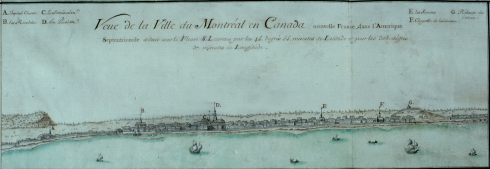
I began by taking us back to seventeenth century Montréal.

The location of the Island of Montréal shaped the connectivity of the city. At the junction of the St. Lawrence River, the Island was connected to the continental interior through the Great Lakes and a vast network of waterways. And to the east, the St. Lawrence River flows toward the Atlantic Ocean. Founded in 1642, initially as a religious site, Fort Ville-Marie gradually developed into an important site for French settlement, expressions of religious devotion, a launching place for military and exploratory expeditions, and a gateway to the vast continental interior. Capitalizing on the fluid nature of the nearby river, the contours of the fort, patterns of dwelling locations, street directions, and other urbanizing development captured and encouraged this natural mobility. The city’s location in a territory dominated by dynamic Indigenous communities, including the Wendat, Anishinaabe, and the Haudenosaunee, also had a significant impact on its development. And the individuals who came to inhabit this space, embodied and capitalized on the city’s advantageous location and its interconnected character.
This reality is particularly clear in the growth of the fur trade and the city’s role in this enterprise. More than any other enterprise, this commercial activity became a part of the everyday fabric of the city. Central to the expansion and success of this trade, were the relationships created by the city’s French inhabitants with diverse Indigenous peoples, and other French and European settlers in North America and across the Atlantic. Across several generations, the extended family of prominent Montréal merchant, Ignace Gamelin Jr., built an intercontinental and trans-Atlantic network that capitalized on, reflected, and contributed to the city’s growth as an economic hub.
But uncovering the threads and interactions that built a city like Montréal can be difficult. And it can be maddening to try to find the details that you want, and to untangle the information you uncover. However, casting a wide net to trace individual and family activities across time and space can reveal the wide spatial networks that helped to constitute “empire.” Following the threads of these relationships, wherever they take us, layering and connecting macro- and micro-scales of analysis and perspectives, can uncover dense social and commercial networks, which grew across continental and imperial spaces, following the riverine geography of North America, to connect Indigenous and European settlements, empires, private endeavours, and imperial projects.
Rather than thinking of a world defined by borders and boundaries, I found that it was more useful to trace “paths carved, and threads followed.”
By reconstructing the layered and interconnected networks created by a prominent merchant family, as well as the relationships developed by other members of Gamelin Jr.’s household, we can catch glimpses of the different ways that diverse individuals specifically and strategically participated in and contributed to the development of the fur trade, a North American enterprise, which significantly influenced Montréal’s growth and character. A microhistorical study of the local, continental, and trans-Atlantic networks established by a family like the Gamelins, which pays attention to and traces the overlapping, interconnected, and intricate relationships, big and small, that knit together the city, shows in microcosm how diverse goods, ideas, interests, and peoples from the Great Lakes, the French West Indies, Québec, and La Rochelle came to traverse and inhabit one space - Montréal.

What I discovered in this research is that utilizing methods of social network analysis, based on the exploration of diverse personal, commercial, and administrative documents, has a lot more to tell us then simply stories of genealogy. These households emphasize the ways that individual relations were inextricably tied to the growth, character, and physical contours of urban spaces like Montréal. Probing individual lives, interactions, and activities, which gave texture to everyday life, can give us insight into much larger questions and understanding of the expected and unexpected ways that places and spaces came together as a result of human behaviour and how they evolved over time.
So how do we take a method that centres on individual relations and household spaces and apply it to a slightly more abstract and evolving geospatial conceptions of a particular region.
On the surface, a study of individual interactions and relationships on the ground in Montréal, compared to a study of growing geospatial understanding of the Great Lakes in France, and subsequent “officially” commissioned mapped representations of this region, might seem difficult to reconcile. Although the temporal and geographic boundaries of both studies are similar, individual relationships along the streets of an urbanizing Montréal, which created the texture of daily life, seem to take place in a different realm than imperial conversations and macro-scale deliberations about spatial conceptions, territorial sovereignty, and so forth. However, as I traced individual movements, transactions, and relations from Montréal further into the continental interior, I wanted to understand how people understood, interacted with, described, and shaped their surroundings, the places they encountered, and how these experiences and understandings were communicated along the intricate waterways of the continent, back to Montréal, or across the Atlantic to France. And I wanted to elucidate how this information was used in local, continental, or empire-wide contexts. As I moved forward in my new research direction, I found that I was asking many of the same questions, and the experiences and networks of communication created by people I had spent years learning about kept pushing their way to the surface. Rather than focusing on peoples’ movements, relationships, etc… I centered particular maps to try to uncover their genealogy. That is, the movement, use, reuse, and influence of depictions over time, to uncover what this trajectory, with its changing and enduring characteristics, can tell us about how people interpreted, presented, and shaped space, physically and conceptually.

Given its significant role in the connectivity and evolution of North America, particularly in the French imperial context, I decided to focus on cartographic depictions of the Great Lakes region.
Applying Igor Kopytoff’s (1986) concept of a “cultural biography of things,” this project is reconstructing the genealogical trajectory of the mapping of the Great Lakes. Layering different perspectives, sources, and scales of analysis and comparing curated imperial geospatial interpretations with individual on-the-ground realities can elucidate how French historical maps came together, the diverse processes of information selection, and what factors influenced their production in the seventeenth and eighteenth centuries.
Although this research is firmly situated in the seventeenth and eighteenth centuries, my guiding methodology, which layers macro and micro-historical perspectives, to understand how individuals interacted with and influenced the world around them, can be applied to other places and time periods to uncover how peoples see, experience, and influence the spaces they inhabit.
For example, I grew up in the east end of Toronto. Generations of families built their lives in the houses that line the neighbourhood’s streets, which are now home to new families, who are altering and adjusting these spaces to suit their own needs and interests.

Individuals did and continue to add layers of texture to the history of this neighbourhood, and to other neighbourhoods around Toronto and in other cities. Tracing these individuals, their activities, and their occupations brings these dwellings, and by extension these neighbourhoods, to life. Through an understanding of these peoples, we can uncover alternative and expanded perspectives on a building we pass each day, the namesake of our favourite park, or the reason behind the curve of the street we live on. This kind of information allows for the exploration of the lives of the diverse peoples who helped to build Toronto or other spaces that we know today. We cannot separate the people from the place, because they shape the place, and people have a lot more to tell us.
In the little details, the echoes of different voices, the seemingly mundane specifics of everyday interactions, or fleeting and evolving references and depictions of an “unfamiliar” world in historical maps produced in France, it is possible to piece together how people participated in, reacted to, and interpreted the world, or indeed worlds, around them and their place within them.


Comments